
Long before the modern lighthouse made its appearance, the use of ranges as aids to navigation had a long history in Charlottetown Harbour. A range is simply a line defined by two points and early sailors learned to find safe passages and avoid hazards by lining up points on the shore. Both natural and man-made features could be and were used. Church steeples, flagpoles and prominent barns and houses provided reference points, as did prominent cliffs, rocks and trees. For example, ensuring that one kept to the east of a line formed by lining up Dockendorff’s barn on York Point with the headland below Fort Amherst meant that you were safely clear of Trout Rock, a shallow reef off Holland Cove. Before charts were prepared captains exchanged information about these ranges to help one another and the information was later formalized in published sailing instructions. At a time when navigation buoys often drifted off location ranges were a safer method of knowing where you were.
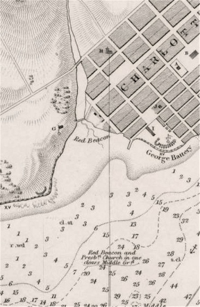
Detail from 1843 Bayfield Chart showing Presbyterian Church range
When the first detailed charts of Charlottetown Harbour were prepared by George Wright in 1839 and Captain Bayfield in 1843 information concerning ranges was an important part of the information included on the charts. The ranges established then are not exactly in the same location as the current ranges marked by the present range lights in Charlottetown harbour but they performed an identical function.
Take the 1846 Bayfield chart for instance: Running into the harbour from Hillsborough Bay one was instructed to line up two white houses on May Point (now Lewis Point) with the edge of the bluff at Brighton. That course kept you safely in the channel through the harbour entrance. When you were able to line up a red beacon on the shore near the southern end of West Street with the spire of the Presbyterian Church you should turn to follow that line until, looking behind you could see a white beacon on the shore of Canceau Point line up with Mckinnon’s House just west of Warren Cove. That would bring you to safe anchorage off the town. A later edition of the chart suggests that lining up the flagpole of Government House with St. Dunstan’s College would be a better line, the red beacon on West Street apparently being no longer in place.
Some Charts included small sketches of what to look for as you approached the harbour. The detail below from the 1843 Chart shows the location of Dockendorff’s barn lined up with Canceau Point as seen from the harbour mouth.
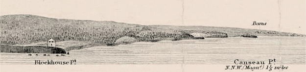
Detail from 1843 Bayfield Chart
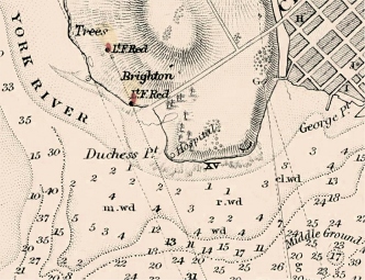
Detail from 1980 chart showing new range lights at Brighton
The modern siting of the ranges and the erection of dedicated range lights began in 1889 when two structures housing lights were built in Brighton. Known as Brighton Beach Front Range (at the west end of York Lane) and Brighton Beach Rear Range slightly further north on what had been the grounds of the Asylum the initial structures were simply masts with a lantern. These rudimentary aids to navigation were soon replaced by skeleton towers and later by more familiar lighthouse towers. The rear tower was burned in a fire in June 1933 suspected of having started in some defect in t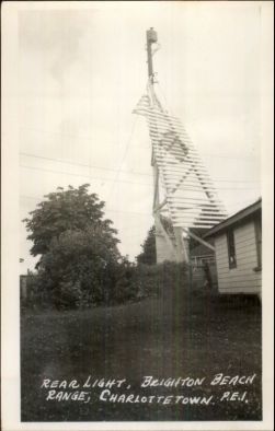 he light apparatus. Firemen were unable to save the building from the flames that also threatened nearby cottages owing to a lack of water at the site. A temporary tower (shown in a 1950s photo) marking the rear range was erected and survived until 1968 when the current concrete tower, an “apple core” design, was built. Over the years the front tower has been slightly re-located at least twice to deal with coastal erosion and has recently undergone renovations which recognize its heritage character. Since the lamps were first installed the quality of the lights installed in to towers has been steadily improved and the Brighton Range lights can now be seen well out in Hillsborough Bay although the development of the area has meant that there are now a great many competing lights along the shores of the harbour.

Brighton Beach Front Range light. Raphael Tuck postcard ca. 1913.
Meanwhile, across the harbour the range at Mackinnon’s Hut was relocated from Canceaux Point to Warren Cove in 1907 with two identical buildings constructed. Using the new locations meant that only two ranges were required rather than several when only natural features or privately owned structures established the lines of safe passage. The new miniature lighthouse structures were quickly adopted as another attraction for cross-harbour excursions. Although when built the small buildings were located in open fields and were visible from several vantage points the growth of trees has meant that they are not easily seen unless one is directly on the line of the two lights in the towers. (Click on any image for larger display)


")
A century after being put in place many of the range structures are in danger of being replaced by steel towers or eliminated completely. While GPS equipment and electronic navigation have made the task easier there are few better ways to ensure a safe passage into a port than riding the ranges.

Pingback: Solving a Postcard History Mystery | Sailstrait
Pingback: Where was “Three Miles from Charlottetown”? – STRAITPOST
Pingback: The Spaniel that went to Sea – And the Captain that went to Court | Sailstrait
Pingback: The Fort Lot: One of the Island’s Special Places | Sailstrait
Pingback: The Governor’s Island Lighthouse: A not very good idea that was luckily not pursued | Sailstrait